
News
The 3D map revealing the future of the Catalan coastline: large areas could be underwater before the end of the century
An interactive map is changing the way we understand the climate crisis on the Catalan coast.
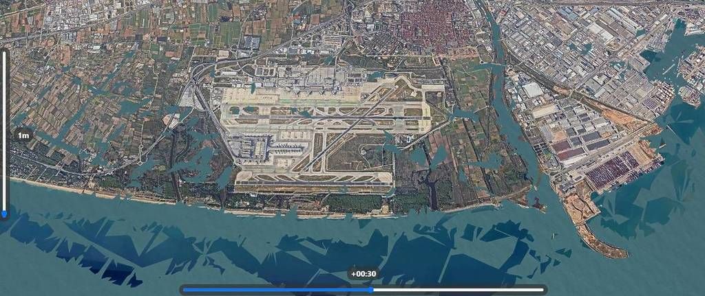
The Sea Level Rise 3D Map tool, created by Japanese engineer Akihiko Kusanagi, makes it possible to visualise in three dimensions what would happen if sea level continues to rise. And the images are as clear as they are alarming: broad stretches of the coastline could be submerged before the end of the century.
The simulator shows that, with a rise of only half a metre, urban areas, infrastructure and natural spaces in the Llobregat and Ebro deltas would already be at risk. If the rise reaches one metre, the map depicts a scenario in which beaches, wetlands and coastal residential areas disappear beneath the water, completely transforming Catalan geography.
Scientists from Medecc (the Mediterranean network of climate-change experts) warn that the Mediterranean is warming 20% faster than the global average, accelerating ice melt and, with it, sea-level rise. At the same time, reports from the Observatorio de la Sostenibilidad place Catalonia among the Spanish regions with the most critical infrastructure in flood-prone areas.
The contrast with official maps from the Agència Catalana de l’Aigua (ACA) adds complexity to the debate. Although these indicate more limited risks, climate projections paint a far more uncertain future.
The question hanging in the air is simple and urgent: are we planning our cities and coastlines for the climate of the present or that of the future? The 3D map does not provide answers, but it makes clear that time — and the sea — are already running.